Mining waste


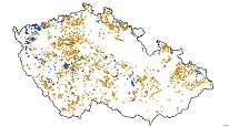
The ArcGIS Server service displays the localization and information on individual registered mining waste facilities in the Czech Republic. The colour scale represents different categories and the extent of their exploration.
service
https://registry.geology.cz/id/TEZEBNI_ODPADY-IUM-SDE-SER
ESRI_MAP
1.3.0
GEMET - INSPIRE themes, version 1.0:
 CGS Geoscientific themes:
ISO 19119:
GEMET - Concepts, version 3.1:
CGS Geoscientific themes:
ISO 19119:
GEMET - Concepts, version 3.1:
12.04,
48.515,
18.848,
51.344
creation: 2013-01-15
Ing. Martin Paleček
Leitnerova 204/22,
Brno,
602 00,
Česká republika
tel: +420543429261
email:
martin.palecek@geology.cz
Role: point of contact
Klárov 131/3,
Praha 1,
118 00,
Česká republika
tel: +420257089411
email:
metadata@geology.cz
Role: custodian
Data Quality
Constraints
Metadata about metadata
561e1cdc-7aa0-49a1-aa22-110c0a010852
Mgr. Pavla Kramolišová
Kostelní 364/26,
Praha 7,
170 00,
Česká republika
tel: +420 234 742 161
email:
pavla.kramolisova@geology.cz
Role: point of contact
2026-02-27