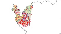
Hydrogeological map of the Aš and Cheb regions (Geoplasma-CE)


WMS service displays hydrogeological units in the region of Aš and Cheb with characteristics of the type of hydrogeological environment and the extent of transmissivity in the unit. The individual layers also show selected archive boreholes with hydraulic data, data from field measurements of physico-chemical properties of groundwater, photo documentation and hydrogeological zones.
service
https://registry.geology.cz/id/PRJ-GEOPLASMA_HYD-SDE-WMS
WMS
GEMET - Concepts, version 2.4:
CGS Geoscientific themes:
ISO 19119:
science > natural science > earth science > geology > hydrogeology
11.975,49.781,12.766,50.402
publication: 2019-12-01
project GeoPLASMA-CE (Shallow Geothermal Energy Planning, Assessement and Mapping Strategies in Central Europe)
Klárov 131/3,
Praha 1,
118 00,
Česká republika
tel: +420257089411
email:
metadata@geology.cz
Role: custodian
Ing. Martin Paleček
Leitnerova 204/22,
Brno,
602 00,
Česká republika
tel: +420543429261
email:
martin.palecek@geology.cz
Role: point of contact
Data Quality
Constraints
Metadata about metadata
6819d4ac-c110-4270-928b-4f550a010852
Mgr. Olga Moravcová, Ph.D.
Klárov 131/3,
Praha 1,
118 00,
Česká republika
tel: +420257089445
email:
olga.moravcova@geology.cz
Role: point of contact
2026-02-27