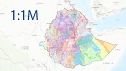
National geological and hydrogeological map of Ethiopia 1 : 1,000,000


Map application provides the results of the national geological and hydrogeological map of Ethiopia, compiled at a scale of 1 : 1,000,000. The geological map is based on existing geological maps at various scales, published literature, remote sensing data, gravity modelling, extensive field verification and newly acquired analytical data sets. Comprehensive hydrogeological factors influencing groundwater distribution and availability have been integrated with the geological data to produce a detailed hydrogeological map at the same scale.
application
https://registry.geology.cz/id/PRJ-CZECHAID_ETIOPIE_1M-DTB-APL
Map
Spatial scope:
ISO 19119:
CGS Geoscientific themes:
GEMET - Concepts, version 3.1:
EGDI Keyword Thesaurus:
33.04,
3.19,
47.981,
14.972
creation: 2024-12-01, publication: 2025-03-13
2024-12-01
-
now
Czech development cooperation in Ethiopia,
To upgrade the existing geological and hydrogeological information across Ethiopia. These long-sustainable outputs will bring a comprehensive and up-to-date knowledge of the geological and hydrogeological environment of Ethiopia with important implications for applied sciences and infrastructure building.
To upgrade the existing geological and hydrogeological information across Ethiopia. These long-sustainable outputs will bring a comprehensive and up-to-date knowledge of the geological and hydrogeological environment of Ethiopia with important implications for applied sciences and infrastructure building.
prof. RNDr. Kryštof Verner, Ph.D.
Klárov 131/3,
Praha 1,
118 00,
Česká republika
tel: +420257089509
email:
krystof.verner@geology.cz
Role: point of contact
Ing. Martin Paleček
Leitnerova 204/22,
Brno,
602 00,
Česká republika
tel: +420543429261
email:
martin.palecek@geology.cz
Role: processor
Klárov 131/3,
Praha 1,
118 00,
Česká republika
tel: +420257089411
email:
metadata@geology.cz
Role: custodian
Data Quality
Interactive National Geological and Hydrogeological Map of Ethiopia (Scale 1 : 1,000,000)
-
Compiled by:
Czech Geological Survey, Czech Republic
Ministry of Water and Energy, Ethiopia
Charles University, Faculty of Science, Czech Republic
SG Geotechnika a.s., Czech Republic
Geological Institute of Ethiopia, Ministry of Mines, Ethiopia
AquaCon Engineering Plc, Ethiopia
-
Geological Map Editors: Kryštof Verner, David Buriánek, Leta Megerssa, František Vacek
Hydrogeological Map Editors: Jiří Šíma, Jan Jelínek, Muhuddin Abdella, Zenaw Tessema
Technical Editor of Interactive Maps: Martin Paleček
-
Compiled by:
Czech Geological Survey, Czech Republic
Ministry of Water and Energy, Ethiopia
Charles University, Faculty of Science, Czech Republic
SG Geotechnika a.s., Czech Republic
Geological Institute of Ethiopia, Ministry of Mines, Ethiopia
AquaCon Engineering Plc, Ethiopia
-
Geological Map Editors: Kryštof Verner, David Buriánek, Leta Megerssa, František Vacek
Hydrogeological Map Editors: Jiří Šíma, Jan Jelínek, Muhuddin Abdella, Zenaw Tessema
Technical Editor of Interactive Maps: Martin Paleček
Constraints
Distribution
prof. RNDr. Kryštof Verner, Ph.D.
Klárov 131/3,
Praha 1,
118 00,
Česká republika
tel: +420257089509
email:
krystof.verner@geology.cz
Role: point of contact
Metadata about metadata
67b5f285-8c3c-46a6-8264-72600a010852
Mgr. Olga Moravcová, Ph.D.
Klárov 131/3,
Praha 1,
118 00,
Česká republika
tel: +420257089445
email:
olga.moravcova@geology.cz
Role: point of contact
2026-05-27