Gravimetry


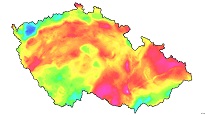
ArcGIS Server service contains information from a gravity field survey of the entire of the Czech Republic at the scale of 1:200,000 and 1:25,000; the detailed scale survey nearly 70 % of the Czech Republic area.
service
https://registry.geology.cz/id/GFY-GRAV-SDE-SER
ESRI_MAP
1.3.0
ISO 19119:
Spatial scope:
GEMET - INSPIRE themes, version 1.0:
 CGS Geoscientific themes:
Free:
gravimetry
Free:
CzechGeo
EGDI
11.938537,48.233711,18.957136,51.354830
creation: 2019-11-11
Ing. Martin Paleček
Leitnerova 204/22,
Brno,
602 00,
Česká republika
tel: +420543429261
email:
martin.palecek@geology.cz
Role: point of contact
Klárov 131/3,
Praha 1,
118 00,
Česká republika
tel: +420257089411
email:
metadata@geology.cz
Role: custodian
Data Quality
Constraints
Metadata about metadata
6009760d-d73c-4e35-a35f-7b920a010852
Mgr. Pavla Kramolišová
Kostelní 364/26,
Praha 7,
170 00,
Česká republika
tel: +420 234 742 161
email:
pavla.kramolisova@geology.cz
Role: point of contact
2026-03-06