Geophysical measurements (surveys, gravimetry, seismic, VES)


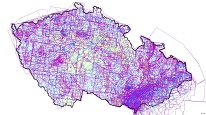
ArcGIS Server service contains information on geophysical measurements made mainly by Geofyzika Brno since the early 1950s. Areas covered by regional surveys are depicted on 1:200 000 scale maps and local small-scale measurements at scale of 1:50 000. Service contains also layers of seismic (2D reflection seismic and well shoots), vertical electric sounding (polygons, lines, points) and localization of the geophysical surveys on the territory of the Czech Republic (both regional and local).
service
https://registry.geology.cz/id/GFY-MERENI_PRZ-SDE-SER
ESRI_MAP
1.3.0
ISO 19119:
Spatial scope:
CGS Geoscientific themes:
GEMET - INSPIRE themes, version 1.0:

Free:
CzechGeo
EGDI
11.7837223412297,47.8441726730581,20.0852358570367,51.4922746621735
creation: 2018-12-01, publication: 2018-12-20
Ing. Martin Paleček
Leitnerova 204/22,
Brno,
602 00,
Česká republika
tel: +420543429261
email:
martin.palecek@geology.cz
Role: point of contact
Klárov 131/3,
Praha 1,
118 00,
Česká republika
tel: +420257089411
email:
metadata@geology.cz
Role: custodian
Data Quality
Constraints
Metadata about metadata
5c1a2a44-e8f4-4fcb-b223-0cb90a010852
Mgr. Olga Moravcová, Ph.D.
Klárov 131/3,
Praha 1,
118 00,
Česká republika
tel: +420257089445
email:
olga.moravcova@geology.cz
Role: point of contact
2026-03-06