Geology for all


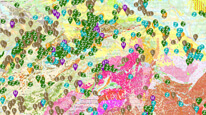
Map application presents hundreds of geosites (geologically interesting sites) in the Czech Republic to a wide public. It includes natural geological outcrops, remains of human activities, mainly of mining origin, caves and karst phenomenon, outdoor geological exhibits, museums with geological expositions, national geoparks and excursion guides (for download in PDF). Every geosite is briefly described and accompanied by a photo, note of its protection and other references. For more special purposes the layer with thousands of other important geological localities and links to its detailed web pages is presented. It is possible to turn on also geological map (1 : 50,000) of the Czech Republic.
application
https://registry.geology.cz/id/POP-POPULARIZACE_G-SDE-APL_MOBIL
Map
GEMET - INSPIRE themes, version 1.0:
 GEMET - Concepts, version 3.1:
Spatial scope:
ISO 19119:
CGS Geoscientific themes:
GEMET - Concepts, version 3.1:
Spatial scope:
ISO 19119:
CGS Geoscientific themes:
Free:
geological map
geological site
geopark
geological exposition
11.99,48.253,18.91,51.247
creation: 2018-09, publication: 2018-11-06
RNDr. Markéta Vajskebrová, Ph.D.
Klárov 131/3,
Praha 1,
118 00,
Česká republika
tel: +420257089444
email:
marketa.vajskebrova@geology.cz
Role: point of contact
Ing. Radek Svítil
Klárov 131/3,
Praha 1,
118 00,
Česká republika
tel: +420 257 089 448
email:
radek.svitil@geology.cz
Role: processor
Ing. Martin Paleček
Leitnerova 204/22,
Brno,
602 00,
Česká republika
tel: +420543429261
email:
martin.palecek@geology.cz
Role: processor
Klárov 131/3,
Praha 1,
118 00,
Česká republika
tel: +420257089411
email:
metadata@geology.cz
Role: custodian
Data Quality
The application is based on CGS own technology to display map services using ESRI API 3.x. Its functionality and design are optimized for touch devices and small displays. Geolocation support makes the application suitable for field use. Base maps - detailed topographic maps and aerial photos - are provided by ČÚZK.
Constraints
Metadata about metadata
5bd9943f-e2ec-4d59-b6db-6a490a010852
Mgr. Olga Moravcová, Ph.D.
Klárov 131/3,
Praha 1,
118 00,
Česká republika
tel: +420257089445
email:
olga.moravcova@geology.cz
Role: point of contact
2026-03-18