Soil map 1 : 1,000,000


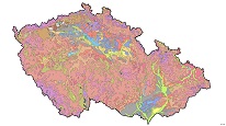
ArcGIS Server Service provides CGS - Soil map at a scale of 1:1M has been compiled by Milan Tomášek and published with a publication Soils of the Czech Republic (3rd edition, Czech Geological Survey, 2003). Part of this map service is a layer describing soil grain size.
service
https://registry.geology.cz/id/NGMD-PED_1M-SDE-SER
ESRI_MAP
CGS Geoscientific themes:
ISO 19119:
GEMET - INSPIRE themes, version 1.0:
 GEMET - Concepts, version 3.1:
11.940987516,48.2353768789,17.9248724542,51.2951336163
creation: 2012-02-01
Ing. Martin Paleček
Leitnerova 204/22,
Brno,
602 00,
Česká republika
tel: +420543429261
email:
martin.palecek@geology.cz
Role: point of contact
Klárov 131/3,
Praha 1,
118 00,
Česká republika
tel: +420257089411
email:
metadata@geology.cz
Role: custodian
Data Quality
Constraints
Metadata about metadata
5af2bb7e-fcc4-49a8-b182-64b80a010852
Mgr. Pavla Kramolišová
Kostelní 364/26,
Praha 7,
170 00,
Česká republika
tel: +420 234 742 161
email:
pavla.kramolisova@geology.cz
Role: point of contact
2026-02-27