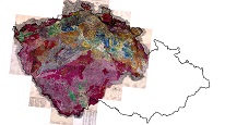
Geological maps of the Crown Lands of Bohemia 1 : 144,000 (raster)


ArcGIS Server service for accessing the Geological maps of the Crown Lands of Bohemia at a scale of 1 : 144,000 from the area of Bohemia (so called Haidinger maps).
service
https://registry.geology.cz/id/NGMD_ARCH-GEOCR144_R-GDB-SER
ESRI_MAP
GEMET - INSPIRE themes, version 1.0:
 CGS Geoscientific themes:
ISO 19119:
CGS Geoscientific themes:
CGS Geoscientific themes:
ISO 19119:
12.08,
48.59,
16.77,
51.06
publication: 2017
Klárov 131/3,
Praha 1,
118 00,
Česká republika
tel: +420257089411
email:
metadata@geology.cz
Role: custodian
Ing. Martin Paleček
Leitnerova 204/22,
Brno,
602 00,
Česká republika
tel: +420543429261
email:
martin.palecek@geology.cz
Role: point of contact
Data Quality
Constraints
Metadata about metadata
5a325ecf-f1c8-4e9b-8dce-7bbc0a010852
Ing. Lucie Kondrová, Ph.D.
Klárov 131/3,
Praha 1,
118 00,
Česká republika
tel: +420257089434
email:
lucie.kondrova@geology.cz
Role: point of contact
2026-02-27