Geoscience maps 1 : 25,000


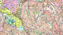
The map server application displays the results of geological mapping of the Czech Republic at a scale of 1: 25,000 (GEOČR25), which has been going on since 1999 to the present. These include vector geological maps depicting both surface geology as well as bedrock geology (maps with / without quaternary cover). Geological mapping at a scale of 1: 25,000 is carried out regionally, in defined areas of interest (a unified regional legend is available for each area of interest). As of March 2022, data is available from the regions of the Brno agglomeration, Český ráj (Bohemian Paradise) – Krkonoše (The Giant Mountains) - Liberec, Jeseníky Mountains, Křivoklát - Brdy, Lugicum, Moldanubicum, Moravia, Polabí (the Elbe region) and Žďárské vrchy (Highlands of Žďár).There is an overview map layer of the mapped areas in the application. The raster geological maps 1: 25,000 (in the S-JTSK coordinate system) with legends and the full map citations are also accessible from this application. These include both archive maps (produced before 1999) and maps generated from the above-mentioned vector map data. Archive maps (rasters) of geological maps at a scale of 1: 25,000 in the S-42 coordinate system (in the Gauss-Krüger projection) are also accessible in the application, inclusive of displaying their legends.
application
https://registry.geology.cz/id/NGMD-GEOCR25_G-SDE-APL
Map

11.99,48.253,18.91,51.247
creation: 2013, publication: 2013, revision: 2021
2008
-
now
Public access to data.
Ing. Martin Paleček
Leitnerova 204/22,
Brno,
602 00,
Česká republika
tel: +420543429261
email:
martin.palecek@geology.cz
Role: processor
Mgr. Lenka Kociánová, Ph.D.
Leitnerova 204/22,
Brno,
602 00,
Česká republika
tel: +420543429223
email:
lenka.kocianova@geology.cz
Role: point of contact
Klárov 131/3,
Praha 1,
118 00,
Česká republika
tel: +420257089411
email:
metadata@geology.cz
Role: custodian
Data Quality
The English version was created and published in 2014, out of operation since 11/2018.
Constraints
Metadata about metadata
5033a14c-febc-46aa-ae8f-0da40a010817
Mgr. Pavla Kramolišová
Kostelní 364/26,
Praha 7,
170 00,
Česká republika
tel: +420 234 742 161
email:
pavla.kramolisova@geology.cz
Role: point of contact
2026-02-27