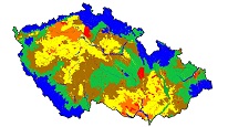
Groundwater vulnerability to drought


Web Map Service (WMS) displaying vulnerability of the quantity of groundwater resources to drought in the Czech Republic.
service
https://registry.geology.cz/id/PRJ-HYD_ZRANITELNOST-SDE-WMS
WMS
1.3.0
ISO 19119:
Spatial scope:
CGS Geoscientific themes:
GEMET - Concepts, version 3.1:
11.939,
48.231,
18.958,
51.355
creation: 2023-09-01
Ing. Martin Paleček
Leitnerova 204/22,
Brno,
602 00,
Česká republika
tel: +420543429261
email:
martin.palecek@geology.cz
Role: point of contact
Klárov 131/3,
Praha 1,
118 00,
Česká republika
tel: +420257089411
email:
metadata@geology.cz
Role: custodian
Data Quality
The map service shows the vulnerability of the quantity of groundwater resources to drought for catchments of the 4. order (finest subdivision of catchments in Czech Republic), hydrogeological districts, floodplains, and municipalities supplied from household groundwater resources. Layer is based on balance between dynamic groundwater resources and groundwater consumption. For groundwater resources the layer of base flow in a dry season is used. Concerning water consumption
The evidence of groundwater withdrawals is used. For municipalities with individual household water supplies, the water withdrawal is calculated from the number of inhabitants and the national average consumption of drinking water per inhabitant. Groundwater withdrawals in the presented map are assigned to environments by geographic position, although the groundwater is often withdrawn from multiple superimposed environments in an unknown ratio (Quaternary fluvial sediments vs. bedrock). The map service should serve as an information document, especially when planning the development of regions. In the case of a specific location (local scale), data should be verified by a local investigation, including field measurements.
The evidence of groundwater withdrawals is used. For municipalities with individual household water supplies, the water withdrawal is calculated from the number of inhabitants and the national average consumption of drinking water per inhabitant. Groundwater withdrawals in the presented map are assigned to environments by geographic position, although the groundwater is often withdrawn from multiple superimposed environments in an unknown ratio (Quaternary fluvial sediments vs. bedrock). The map service should serve as an information document, especially when planning the development of regions. In the case of a specific location (local scale), data should be verified by a local investigation, including field measurements.
Constraints
Metadata about metadata
650016cc-11c8-4817-a813-3d4d0a010852
Mgr. Pavla Kramolišová
Kostelní 364/26,
Praha 7,
170 00,
Česká republika
tel: +420 234 742 161
email:
pavla.kramolisova@geology.cz
Role: point of contact
2026-02-27