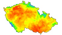
Base flow


ArcGIS Server service displaying longterm mean base flow for the period 1991-2020 and base flow in the dry period
service
https://registry.geology.cz/id/PRJ-HYD_ODTOK-SDE-SER
ESRI_MAP
ISO 19119:
CGS Geoscientific themes:
Spatial scope:
GEMET - Concepts, version 3.1:
Free:
mean base flow
base flow in the dry
11.939,
48.234,
18.948,
51.353
creation: 2023-09-01
2023-08-01
-
now
Ing. Martin Paleček
Leitnerova 204/22,
Brno,
602 00,
Česká republika
tel: +420543429261
email:
martin.palecek@geology.cz
Role: point of contact
Klárov 131/3,
Praha 1,
118 00,
Česká republika
tel: +420257089411
email:
metadata@geology.cz
Role: custodian
Data Quality
The map service displays 2 layers:
1.Longterm mean base flow for the period 1991-2020 (mean dynamic groundwater resources) - the mean values of the long-term base flow (BF), i.e. dynamic groundwater resources (l/s/km2) for the entire Czech Republic. It was generated from the long-term mean annual precipitation for the last thirty-year normal (period 1991-2020) on the basis of a tight relationship between the precipitation totals and total flow and base flow indexes (BFI) specific for individual hydrogeological districts determined by hydrograph separation on 480 profiles of Czech hydrometeorological institute (CHMI). Spatial resolution is 1 km2. According to the verification on 480 profiles of CHMI, the actual value of the base flow falls within the variance of ± 40% of given BF value. This is acceptable since BF is changing more than 1 order of magnitude within Czech Republic.
2. Base flow in the dry period (dynamic groundwater resources in dry year) - the base flow in a dry season, which was generated from layer of long-term mean base flow and the index of flow in dry year (M) for individual districts. The M index values were determined as the ratio between the base flow in the driest year of the decade 2010-2019 to the mean base flow derived from the separation of hydrographs on 480 profiles on watercourses in the Czech Republic. The values of the base flow in the dry season are significantly lower than the mean base flow, especially in lowland areas of the Czech Republic.
Constraints
Metadata about metadata
65001376-1148-4457-93b5-3d4d0a010852
Mgr. Pavla Kramolišová
Kostelní 364/26,
Praha 7,
170 00,
Česká republika
tel: +420 234 742 161
email:
pavla.kramolisova@geology.cz
Role: point of contact
2026-02-27