Geothermal energy potential


The map application shows the Czech Republic‘s geothermal potential and its limitations. Map layers indicating the temperature distribution (°C) at various depths ranging from 400 m to 5000 m, a map of heat flux distribution (mW.m-2) at the surface, and a map of the thermal conductivity of rocks (W. m-1. K-1) illustrate the geothermal potential. The application also includes thematic layers depicting limitations and conflicts of interest, which are constraints on the use of geothermal energy due to natural hazards (e.g. floodplains, areas with unstable bedrock and prone to landslides), technical constraints on the construction of geothermal installations (existing infrastructure, mining, etc.), and legislative restrictions (protection of nature and water, etc.).
application
https://registry.geology.cz/id/PRJ-GFY_GEOTERM-SDE-APL
Map
ISO 19119:
GEMET - INSPIRE themes, version 1.0:
 EGDI Keyword Thesaurus:
CGS Geoscientific themes:
Spatial scope:
GEMET - Concepts, version 3.1:
EGDI Keyword Thesaurus:
CGS Geoscientific themes:
Spatial scope:
GEMET - Concepts, version 3.1:
Free:
geothermal maps
heat flow
11.99,
48.253,
18.91,
51.247
creation: 2022-03-01, publication: 2022-03-30
Projekt TK02010092 - Analýza potenciálu geotermální energie ve středních a velkých hloubkách na území ČR na základě disponibilních údajů.
Mgr. Jan Holeček, Ph.D.
Geologická 577/6,
Praha 5,
152 00,
Česká republika
tel: +420251085240
email:
jan.holecek@geology.cz
Role: point of contact
Ing. Martin Paleček
Leitnerova 204/22,
Brno,
602 00,
Česká republika
tel: +420543429261
email:
martin.palecek@geology.cz
Role: processor
Klárov 131/3,
Praha 1,
118 00,
Česká republika
tel: +420257089411
email:
metadata@geology.cz
Role: custodian
Data Quality
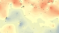
Maps of the geothermal potential were compiled based on geothermal measurements in 362 deep boreholes in the Czech Republic and adjacent areas, on knowledge of the depth and spatial extent of sedimentary basins, and on the territory‘s geological structure. Due to the uneven distribution of boreholes in the territory, the geothermal maps are more accurate near boreholes, with geological uncertainty increasing with distance. Therefore, the map also depicts a layer of boreholes that were used to create the geothermal maps.
Constraints
Metadata about metadata
620f85ad-9660-42ef-874d-6f450a010852
Mgr. Olga Moravcová, Ph.D.
Klárov 131/3,
Praha 1,
118 00,
Česká republika
tel: +420257089445
email:
olga.moravcova@geology.cz
Role: point of contact
2026-05-20