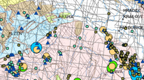
Radiometric anomalies and CSUP survey


The map application makes available survey, radiometric and radioecological data of roughly fifty years of work of the former company ČSUP (Czechoslovak Uranium Industry). The maps and attribute tables describe radioactive objects (RO) with radiometric measurements (gamma, radon) and verification works (wells, shafts, trenches, mine works). According to the evaluation of the works carried out, the ČSUP allocated an anomalous area of radioecological risk. On the basis of the data of ČSUP, an estimate of the size of the Rn index was currently made for objects with radon measurement. Another topic is the radiometric research of ČSUP in four categories according to the details of the measurement. The application is complemented by a composition of vectorized maps of the CSUP at a scale of 1:500,000, which show regional geological units, a structural map, a map of U-mineralization and the radioecological risk of geological units.
application
https://registry.geology.cz/id/RANAP-RADANOM-SDE-APL
Map
ISO 19119:
GEMET - INSPIRE themes, version 1.0:

 CGS Geoscientific themes:
Spatial scope:
GEMET - Concepts, version 3.1:
CGS Geoscientific themes:
Spatial scope:
GEMET - Concepts, version 3.1:
Free:
radiometric survey
radiometric anomalies
Československý uranový průzkum (ČSUP)
11.898,
48.46,
18.556,
51.167
creation: 2021-11, publication: 2024-01-08
projekt 388800 "RANAP (radon) - Radiometrické anomálie a prozkoumanost z dat ČSUP"
RNDr. Roman Kujal, Ph.D.
Kostelní 364/26,
Praha 7,
170 00,
Česká republika
tel: +420234742118
email:
roman.kujal@geology.cz
Role: point of contact
Czech Geological Survey
RNDr. Ivana Dudková
Kostelní 364/26,
Praha 7,
170 00,
Česká republika
tel: +420234742113
email:
ivana.dudkova@geology.cz
Role: processor
Ing. Martin Paleček
Leitnerova 204/22,
Brno,
602 00,
Česká republika
tel: +420543429261
email:
martin.palecek@geology.cz
Role: processor
Klárov 131/3,
Praha 1,
118 00,
Česká republika
tel: +420257089411
email:
metadata@geology.cz
Role: custodian
Data Quality
Československý uranový průzkum (ČSUP)
Constraints
Metadata about metadata
619f77f4-b4f0-4de5-becc-664e0a010852
Mgr. Olga Moravcová, Ph.D.
Klárov 131/3,
Praha 1,
118 00,
Česká republika
tel: +420257089445
email:
olga.moravcova@geology.cz
Role: point of contact
2026-02-27