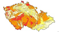
Radon risk map 1 : 500,000 (GEOCR500)


ArcGIS Server Service Radon Risk Map of the Bedrock at 1 : 500 000 scale. WMS shows the prevailing radon index of different types of bedrock: 1. Low (Mesozoic and Tertiary sediments), 2. Intermediate (Quaternary sediments), 3. Medium ( Metamorphic rocks and Palaeozoic sediments), 4. High (Magmatic rocks, except for the Pre-Variscan granitoids – medium index), 5. Tectonic features, 6. Boundaries of regions
service
https://registry.geology.cz/id/NGMD-GEOCR500_RDN-SDE-SER
ESRI_MAP
GEMET - Concepts, version 3.1:
ISO 19119:
GEMET - INSPIRE themes, version 1.0:
 CGS Geoscientific themes:
Free:
CzechGeo
EGDI
11.941,
48.233,
18.953,
51.357
creation: 2012-02-01
Ing. Martin Paleček
Leitnerova 204/22,
Brno,
602 00,
Česká republika
tel: +420543429261
email:
martin.palecek@geology.cz
Role: point of contact
Klárov 131/3,
Praha 1,
118 00,
Česká republika
tel: +420257089411
email:
metadata@geology.cz
Role: custodian
Data Quality
Constraints
Metadata about metadata
5addd75e-eeb8-445b-b3bf-411d0a010852
Mgr. Pavla Kramolišová
Kostelní 364/26,
Praha 7,
170 00,
Česká republika
tel: +420 234 742 161
email:
pavla.kramolisova@geology.cz
Role: point of contact
2026-03-06