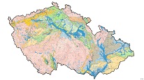
Hydrogeological map of Czechoslovakia 1 : 1,000,000 – territory of the CR (raster)


WMS service displays a map at a scale of 1:1M was compiled by O. Franko, M. Hazdrová, M. Chaloupská, J. Jetel, G. Kačura, E. Kullman, V. Myslil and P. Pospíšil, with the use of H. Daňková’s research material and was published in 1966. It contains information about ground-water data, geological characteristics of rocks, hydrogeological objects, and tectonics. It has been derived from a geological map at a scale of 1:1M. In March 2008 it was published part of the map describing territory of the Czech Republic as a WMS service from the raster data.
service
https://registry.geology.cz/id/NGMD_ARCH-HYD_1M_R-SDE-WMS
WMS
ISO 19119:
CGS Geoscientific themes:
GEMET - Concepts, version 3.1:
Spatial scope:
11.99,
48.253,
18.91,
51.247
publication: 2012-02-01, revision: 2009-07-03
Ing. Martin Paleček
Leitnerova 204/22,
Brno,
602 00,
Česká republika
tel: +420543429261
email:
martin.palecek@geology.cz
Role: point of contact
Klárov 131/3,
Praha 1,
118 00,
Česká republika
tel: +420257089411
email:
metadata@geology.cz
Role: custodian
Data Quality
WMS from the CGS raster data.
O. Franko, M. Hazdrová, M. Chaloupská, J. Jetel, G. Kačura, E. Kullman, V. Myslil and P. Pospíšil (1966): Hydrogeological map of Czechoslovakia 1 : 1,000,000.
O. Franko, M. Hazdrová, M. Chaloupská, J. Jetel, G. Kačura, E. Kullman, V. Myslil and P. Pospíšil (1966): Hydrogeological map of Czechoslovakia 1 : 1,000,000.
Constraints
Metadata about metadata
518b64b1-e3d8-4900-9a4e-1e400a010817
Mgr. Pavla Kramolišová
Kostelní 364/26,
Praha 7,
170 00,
Česká republika
tel: +420 234 742 161
email:
pavla.kramolisova@geology.cz
Role: point of contact
2026-02-27