Slope deformations


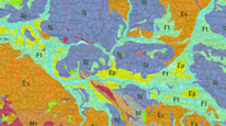
Map server application presents slope deformations (landslides etc.) in the territory of the Czech Republic mapped by CGS (1 : 10,000) or registred in GEOFOND. Other geoscience map layers are also available: geological and geomorphological units, engineering–geological zones, landslide susceptibility map and quarries inventory.
application
https://registry.geology.cz/id/NGMD-RSN-SDE-APL
Map
ISO 19119:
CGS Geoscientific themes:
GEMET - INSPIRE themes, version 1.0:
 GEMET - Concepts, version 3.1:
EGDI Keyword Thesaurus:
Spatial scope:
GEMET - Concepts, version 3.1:
EGDI Keyword Thesaurus:
Spatial scope:
11.99,
48.253,
18.91,
51.247
creation: 2011, revision: 2017-10-03
Veřejný přístup k datům.
Ing. Martin Paleček
Leitnerova 204/22,
Brno,
602 00,
Česká republika
tel: +420543429261
email:
martin.palecek@geology.cz
Role: processor
RNDr. Oldřich Krejčí, Ph.D.
Leitnerova 204/22,
Brno,
602 00,
Česká republika
tel: +420543429263
email:
oldrich.krejci@geology.cz
Role: point of contact
Klárov 131/3,
Praha 1,
118 00,
Česká republika
tel: +420257089411
email:
metadata@geology.cz
Role: custodian
RNDr. Zuzana Krejčí, CSc.
Leitnerova 204/22,
Brno,
602 00,
Česká republika
tel: +420543429220
email:
zuzana.krejci@geology.cz
Role: originator
Data Quality
The English version was created and published in 2014; out of operation since 12/2018.
The Czech version of the map application was remade into Web AppBuilder and published in https mode on 3.10.2017.
revision: 2014, revision: 03 .10. 2017, since 2.2.2022 layer of Quarries inventory, 17.1.2024 URL change.
The Czech version of the map application was remade into Web AppBuilder and published in https mode on 3.10.2017.
revision: 2014, revision: 03 .10. 2017, since 2.2.2022 layer of Quarries inventory, 17.1.2024 URL change.
Constraints
Metadata about metadata
50339320-329c-46c8-86fc-0da40a010817
Mgr. Olga Moravcová, Ph.D.
Klárov 131/3,
Praha 1,
118 00,
Česká republika
tel: +420257089445
email:
olga.moravcova@geology.cz
Role: point of contact
2026-05-20